


| January 22 2025 |
Gulf Coast to Southeast Historic Winter Storm: (1/20 - 1/21)
By: David Hamrick, WPC Meteorologist
Meteorological Overview:
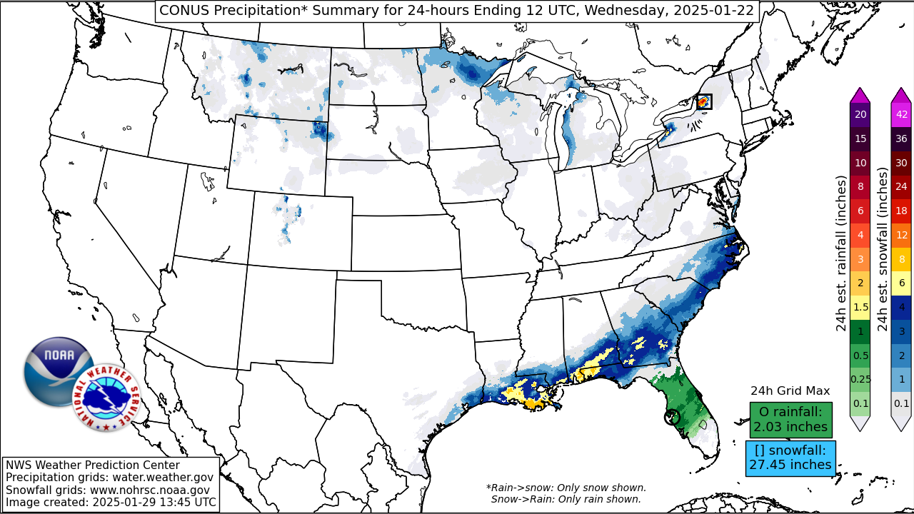
A rare Gulf Coast to Southeast U.S. winter storm resulted in widespread record-breaking snow from coastal southeast Texas eastward to northern Florida, and then extended across eastern North Carolina into the Hampton Roads area of Virginia. Prior to the onset of precipitation, a major surge of arctic air had reached the Gulf Coast region with well below average temperatures across the region and high dewpoint depressions in the boundary layer. An intensifying shortwave disturbance tracked from the Great Basin to western Texas, and a northern stream shortwave merged with this, forming a positively tilted trough axis in combination with favorable right entrance region dynamics in the 250 mb upper jet. The combination of mid-level height falls and strong upper level diffluence led to surface cyclogenesis over the western Gulf on the evening of January 20th and continuing into the 21st, where a 1013 mb surface low was analyzed as of 21Z about 300 miles south of the Louisiana Coast. This surface low and the attendant frontal zone then moved across the Florida Peninsula and then out to sea by 12Z on January 22nd, with the snow moving offshore by that time.
Regional Doppler radars indicated light precipitation developing near the Texas Coast on the afternoon and evening of January 20th, and this became heavier in intensity during the overnight hours into the morning of the 21st across southeast Texas and southern Louisiana. Temperatures were initially above freezing in many of the areas that received significant snow, but very low dewpoints near 10 degrees allowed for about 5-10 degrees of wet bulb cooling, with temperatures falling into the middle 20s to lower 30s. The GOES Geostationary Lightning Mapper (GLM) depicted some instances of thundersnow shortly after 15Z on the 21st across portions of southwestern Louisiana when snowfall rates were likely in excess of one inch per hour, and a rare blizzard warning was issued by the Lake Charles WFO. Observations from the New Orleans International Airport (KMSY) indicated 7 consecutive hours of heavy snow (SN+), including visibility of 1/16th of a mile at 19Z! Winds were generally sustained at 15-20 mph with gusts to 30 mph, creating near blizzard conditions at times.
After the snow ended late on the 21st, the boundary layer decoupled with nearly calm winds and clearing skies. In combination with a fresh snow cover, the morning of the 22nd was accompanied by widespread record cold temperatures across southeast Texas, the southern half of Louisiana, and extending eastward to the Florida Peninsula. A few locations in southern Louisiana had new all-time record low temperatures, including New Iberia at 2F, and Lafayette at 4F. Numerous other locations from southern Mississippi to the Florida Panhandle and southern Georgia also had daily record lows.
Impacts:
This rare winter storm will go down in history as one of the biggest snow events in recorded history, and rivaling the great Gulf Coast snowstorm of February 15, 1895. Many locations set all time snowfall records. Florida set a new all-time record for accumulating snow, with an impressive 10 inches reported in Milton, which is more than double the previous state record of just 4 inches set in 1954! In Louisiana, multiple locations reported double digit snowfall totals, including 11.5 inches in Chalmette, 10.5 inches in Lafayette, and 10 inches in parts of the New Orleans metro area. The New Orleans snowfall was similar in magnitude to the 1895 event, but otherwise surpassed other recorded snowfall events by huge margins. Although snow was the primary precipitation type, portions of southern Texas and northeast Florida were affected by a moderate freezing rain event, with nearly two tenths of an inch of ice accretion in Corpus Christi, Texas, and about a tenth of an inch in Hyde Park, Florida.
During the afternoon of the 21st when the snowfall was most widespread, numerous sections of Interstate 10 were closed, and other sections had either below average speed, or major traffic jams between the greater Houston metro area and Tallahassee, Florida. The same held true for other major highways and Interstates in the region, including portions of I-55, I-59, I-45, I-49, and I-65 throughout and the following night. Numerous road closures continued into January 22nd in the greater New Orleans and Baton Rouge metro areas, as well as Pensacola, Florida and surrounding areas of the western Florida Panhandle. A long stretch of Interstate 95 from southeast Georgia to eastern North Carolina was also heavily impacted by that evening.
In addition to the numerous road closures, hundreds of flights were cancelled as a result of this winter storm, stranding passengers for days in some cases. Schools and universities across the region also had multi-day closures. The 7 inches of snow in Mobile was heavy enough to result in the roof collapse of the abandoned Civic Center, which was already scheduled for demolition.