|
|
 |
 |
||
 |
| Site Map | News | Organization |
| DOC | NOAA | NWS | NCEP Centers: | AWC | CPC | EMC | NCO | NHC | OPC | SPC | SWPC | WPC |
|
|
|
|
|
||
|
| Site Map | News | Organization |
| DOC | NOAA | NWS | NCEP Centers: | AWC | CPC | EMC | NCO | NHC | OPC | SPC | SWPC | WPC |
|
WPC Medium Range Archive
Medium Range Products Valid On:
04/18/2025
(Day 7 PMDEPD: Valid 04/14/2025 to 04/18/2025)
Extended Forecast Discussion
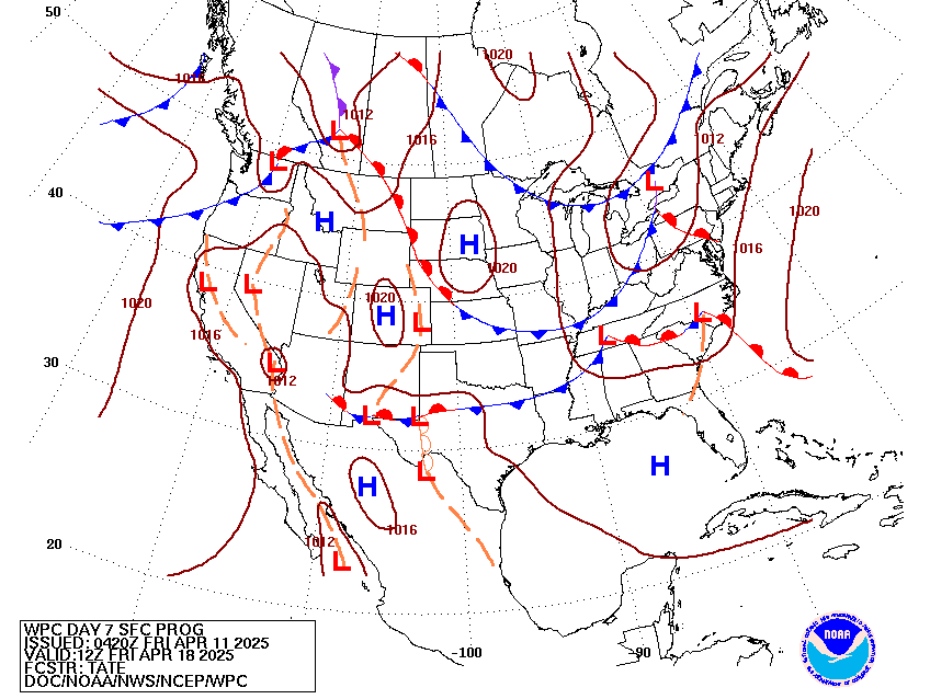
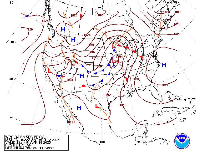
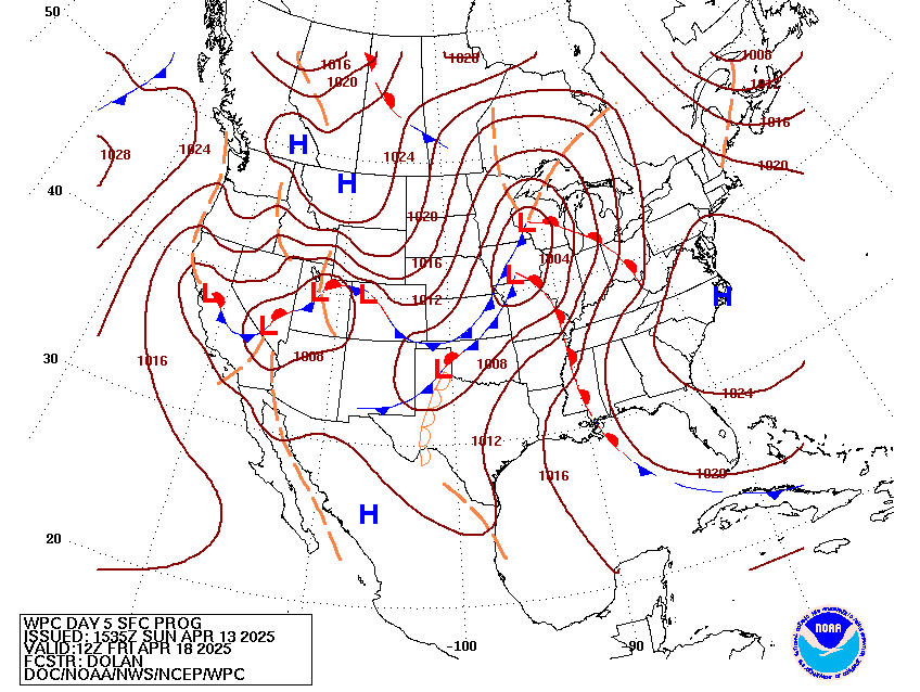
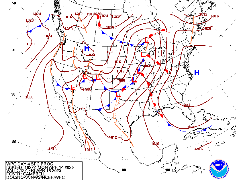
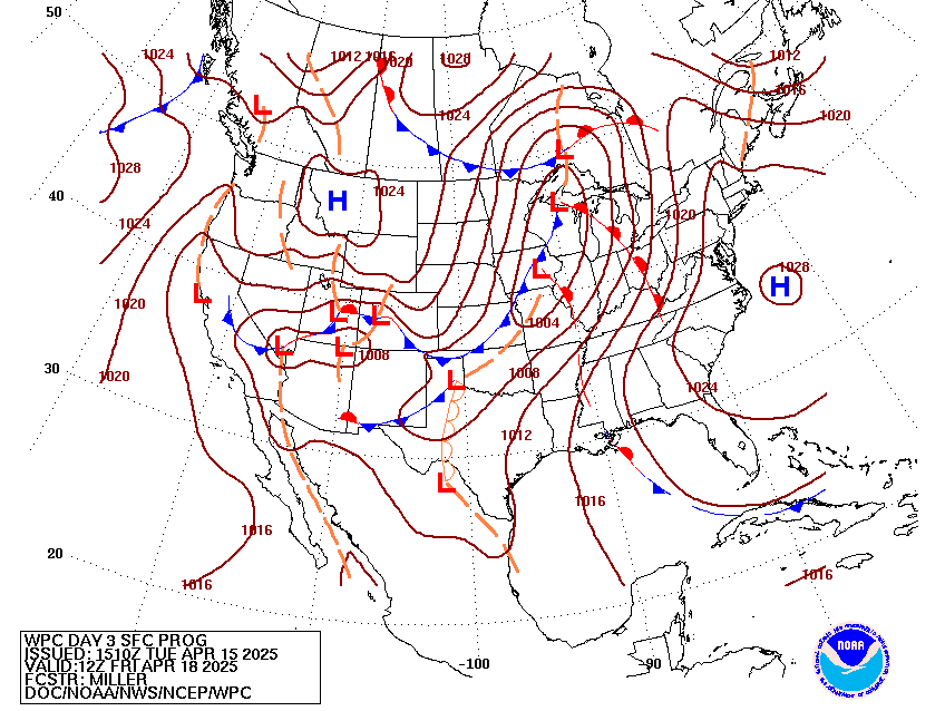
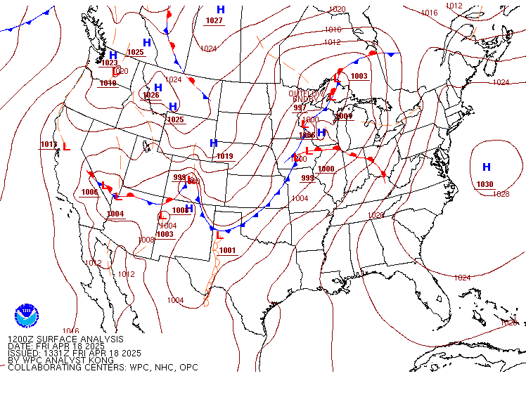
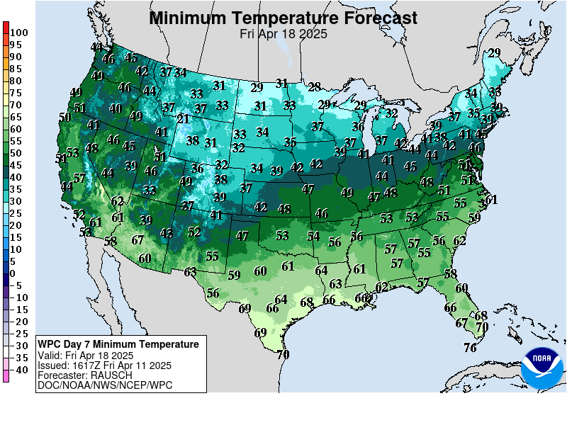
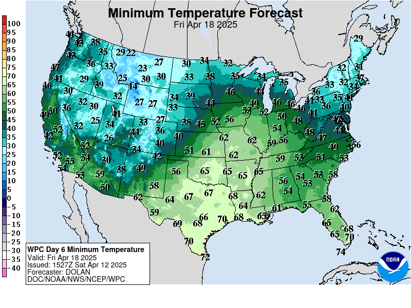
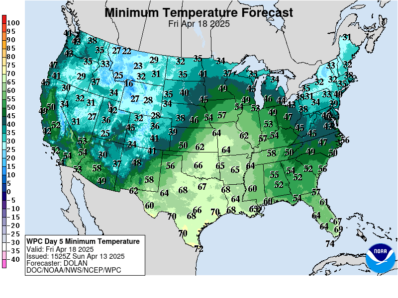
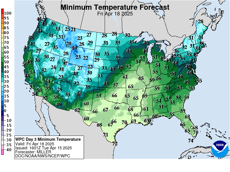
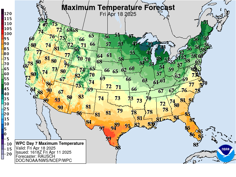
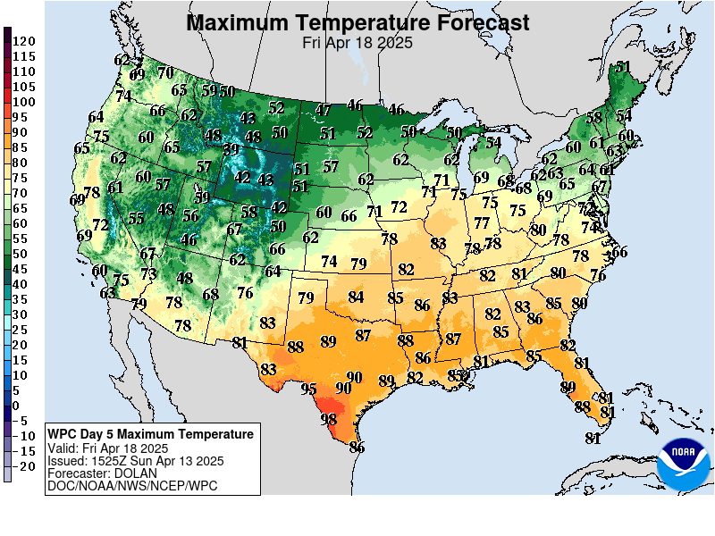
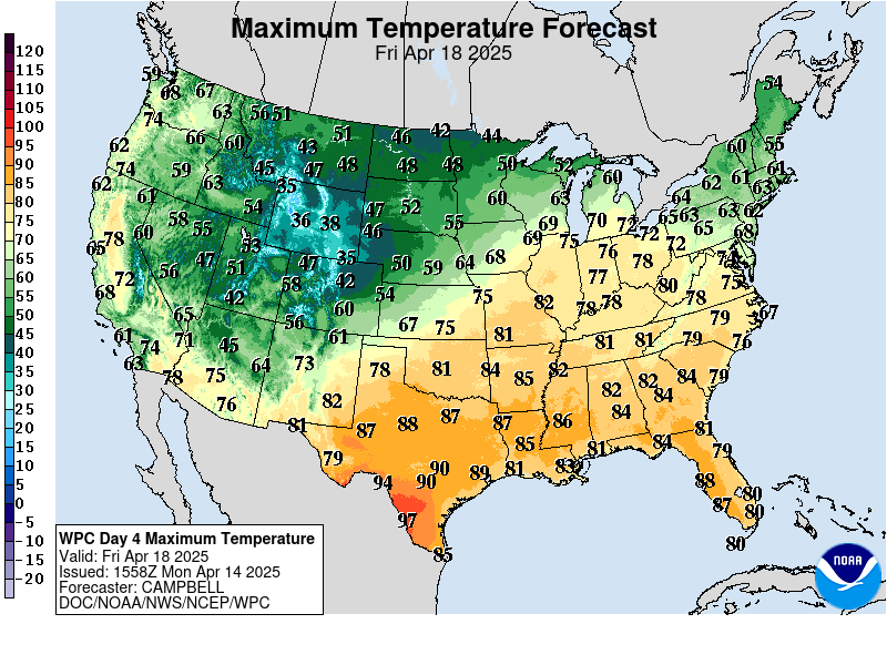
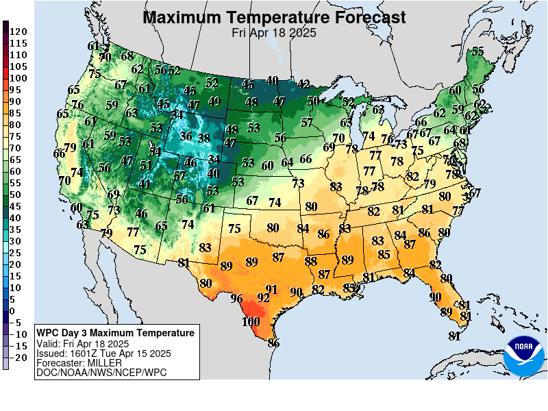
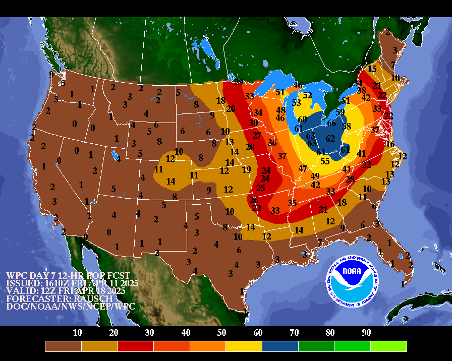
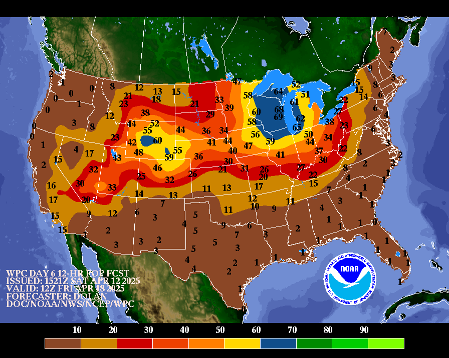
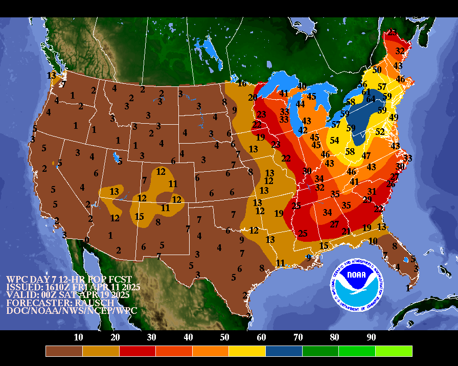
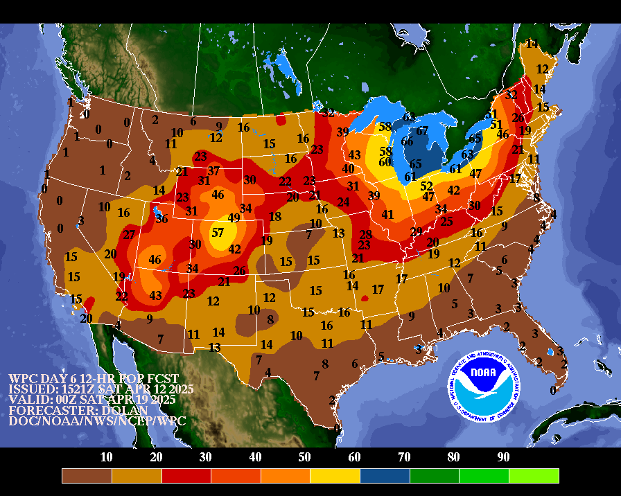
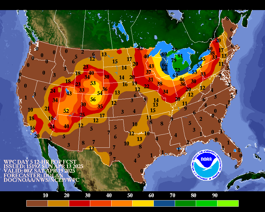
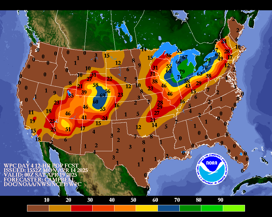
NWS Weather Prediction Center College Park MD 257 PM EDT Fri Apr 11 2025 Valid 12Z Mon Apr 14 2025 - 12Z Fri Apr 18 2025 ...Overview... Guidance agrees rather well for a leading northern stream upper trough and surface low/frontal system that will affect the central through eastern U.S. during the first half of next week. This system will bring mostly light to moderate precipitation on Monday along with potentially severe storms in the Upper Ohio Valley, with a period of brisk winds from the Plains into the Northeast. The western ridge/eastern trough pattern early-mid week should promote warm temperatures over the West and cool weather over the East. From about Wednesday onward there is rapidly increasing spread for the evolution of the next shortwave trough in the series. Somewhat more guidance shows this energy feeding into yet another amplified eastern upper trough by next Friday, leading to another round of rain spreading across the central and eastern U.S. mid- late week, while mean ridging persists over the West. However there is a meaningful minority that shows the energy digging into the West instead of farther eastward, obviously with major differences in the surface/precipitation pattern and temperature anomalies. Meanwhile a weakening southern stream upper low should reach the Southwest by Tuesday with a larger scale upper low lurking offshore southern California for the rest of the week (depending on flow details over the western U.S.). ...Guidance/Predictability Assessment... With the latest guidance clustering well in principle for the leading central-eastern U.S. upper trough and associated system, the primary focus of decision-making today regards the significant guidance divergence that takes place behind the first trough. Looking at available data through the 00Z/06Z cycles, there was a pronounced trend in GFS/GEFS runs toward recent ECMWF/ECens solutions depicting a more amplified eastern U.S. upper trough by late in the week with low pressure gravitating toward the central/upper Great Lakes as of early Friday. The 00Z CMC was a bit westward but similar in principle while the 00Z CMCens and UKMET means fit into this theme albeit in slightly weaker fashion. Some CMC/ECens ensemble members provided a first suggestion of a very different evolution however, with a handful of each digging a lot more trough energy into the West. The 00Z ICON also fit into this scenario. 00Z/06Z ML (machine learning) models showed a dramatic split as well, with a couple (including multiple ECMWF AIFS runs) opting for more western troughing versus the other ML models plus the 00Z AIFS mean favoring the eastern trough. Based on the relatively greater proportion of guidance depicting the eastern trough scenario by late week, which would also represent some persistence of the overall mean pattern, forecast preferences by the latter half of next week trended to a blend of the 00Z ECMWF/CMC and their ensemble means. This led to an early Friday Great Lakes surface system close to the depth recommended by the cluster of ML models with that solution. 00Z/06Z GFS runs and the GEFS mean differed enough from other solutions in the cluster for details to exclude from the forecast. An operational model blend provided a good starting point earlier in the week. New 12Z guidance adds further confusion to the late-week forecast, with the ECMWF and CMC both flipping to the western trough scenario but the ICON adjusting to an intermediate idea of a Plains/central Rockies upper trough by next Friday. On the other hand the 12Z GFS has adjusted very close to the preferred forecast described above and the general surface pattern of the 12Z GEFS/06Z UKMET means are similar to or a bit slower versus preference. ...Weather/Hazards Highlights... A surface low tracking from the Upper Great Lakes Monday through southeastern Canada Tuesday and its trailing cold front will support some precipitation across the east-central and eastern U.S. Monday-Tuesday. An upper trough will provide dynamical support and some instability should pool in the Upper Ohio Valley to potentially produce severe thunderstorms, with damaging winds as the primary threat, per the Storm Prediction Center. Rain rates could possibly reach an inch per hour around Ohio/West Virginia/Pennsylvania, but these should be short-lived as these storms are fast moving and north/east of where heaviest rainfall has occurred in recent weeks. However some non-GFS models are showing a little more of a signal now for locally enhanced rainfall. This is a very small-scale area and a few days out in time so the Days 4-5 EROs maintain no risk areas, but typical terrain sensitivity and trends seem to merit some monitoring over future cycles into the short range. On the backside of the low, temperatures could be cold enough for snow in the U.P. of Michigan Monday and into higher elevations of the Adirondacks and Green and White Mountains into Tuesday. Flow behind the northern tier storm should produce strong and gusty winds over the northern/central Plains into Monday, with some brisk winds reaching into the Great Lakes/Northeast thereafter. A weakening upper low reaching the Southwest by Tuesday may produce some very scattered and light precipitation. Then as surface low pressure develops in the central High Plains and moves east, rain is forecast to spread across the central Plains to Middle Mississippi Valley for midweek. There is still uncertainty with how heavy this rainfall will be and the forecast will continue to be refined with time. Northern stream energy could also produce light precipitation over the Great Lakes region Wednesday, and these features may combine to produce an expanding area of rainfall with varying intensity over the eastern half of the country Thursday- Friday. Depending on how deep the supporting upper trough and possible embedded low become toward the end of the week, it could become cold enough to produce some snow over the Upper Great Lakes. Note that there is a minority potential for an alternate pattern evolution which may lead to less southward extent of precipitation over the East and at the same time greater coverage of rain and higher elevation snow over parts of the West/Rockies (versus the current relatively dry forecast). Continue to monitor forecast updates for any significant trends in the most likely scenario. Mean ridging aloft will favor warmer than average temperatures over the West and expanding into the Plains early-mid next week (up to plus 10-20F or so anomalies for highs), while the upper trough moving into the East will bring cooler temperatures over that part of the country (highs up to 10-15F below normal over parts of the Great Lakes into Appalachians). Warmer than normal temperatures are also likely from southern Texas into the eastern U.S. on Monday ahead of the leading cold front. Forecast confidence rapidly declines by Thursday-Friday. Current forecast preferences would maintain very warm temperatures over the West, as well as the southern half of the Plains into Thursday before frontal passage, while the East would trend below normal again by next Friday. However there is some potential for a cooler trend over parts of the West and less cooling farther east. Rausch/Tate Additional 3-7 Day Hazard information can be found on the WPC medium range hazards outlook chart at: https://www.wpc.ncep.noaa.gov/threats/threats.php WPC medium range 500mb heights, surface systems, weather grids, quantitative precipitation forecast (QPF), excessive rainfall outlook (ERO), winter weather outlook (WWO) probabilities, heat indices, and Key Messages can be accessed from: https://www.wpc.ncep.noaa.gov/medr/5dayfcst500_wbg.gif https://www.wpc.ncep.noaa.gov/medr/5dayfcst_wbg_conus.gif https://www.wpc.ncep.noaa.gov/5km_grids/5km_gridsbody.html https://www.wpc.ncep.noaa.gov/qpf/day4-7.shtml https://www.wpc.ncep.noaa.gov/#page=ero https://www.wpc.ncep.noaa.gov/wwd/pwpf_d47/pwpf_medr.php?day=4 https://www.wpc.ncep.noaa.gov/heat_index.shtml https://www.wpc.ncep.noaa.gov/#page=ovw
|
||||||||||||||||||||||||||||||||||||||||||||||||


