Extended Forecast Discussion
NWS Weather Prediction Center College Park MD
351 PM EDT Fri Oct 24 2025
Valid 12Z Mon Oct 27 2025 - 12Z Fri Oct 31 2025
...Heavy rain possible for the eastern U.S. next week...
...Overview...
The medium range pattern over the lower 48 next week looks
amplified and active. Troughing over the West will continue to
bring unsettled and cool conditions to the region through Monday,
while a compact upper low over the Northeast and a weakening
southern stream low across the Mid-South are forecast as well.
Energy from these three systems will interact into midweek, though
with uncertainty about the resulting pattern across the central and
eastern U.S. as the week progresses. Generally, periods of rain
are likely across the eastern half of the U.S., and timing and
placement of precipitation will continue to be refined in future
forecasts. Meanwhile farther west, rounds of weaker shortwaves and
frontal boundaries will keep particularly the Pacific Northwest wet
through much of the next week.
...Guidance/Predictability Assessment...
Model guidance shows good agreement with the pattern described
above at the start of the medium range period on Monday. However,
models are quick to diverge with the pattern after that, primarily
because of the evolution of energy dropping somewhere southeastward
through the central U.S. by Tuesday and Wednesday. Through the
00/06Z model cycle, the CMC continued its pattern that it has had
in the past several runs, where the energy filters south and a low
cuts off farther southwest of the GFS/ECMWF consensus, and the
UKMET was even farther west of the CMC. The GFS and ECMWF runs took
a faster track with more of an easterly component with the energy,
which then combined with the retrograding trough/low from the East
to form a large upper low in the east-central U.S. by midweek.
There was some spread in the placement and speed of the ensemble
members, but the UKMET especially was farther west than basically
all ensemble members from the EC, GEFS, and even the CMC ensembles.
AI models had various solutions but basically all except the 00Z
Pangu runs (both GFS-based and EC-based) were east of the CMC/UK.
Thus most evidence including the previous forecast pointed to
leaning in the faster GFS/ECMWF direction. The WPC forecast was
based on a blend of the 06Z GFS, 00Z ECMWF, and lesser proportions
of the GEFS and EC ensemble means.
However...12Z model guidance, including the GFS, ECMWF, and EC-
AIFS, now favor a solution where energy dives farther west through
the central U.S., forms a closed low farther southwest of the
previous EC/GFS consensus by Wednesday. This leads to the upper
lows not combining in the east-central U.S. like the previous
forecast issuances have shown. At the surface, this generally seems
to have a weaker coastal low early in the week, but then does not
strengthen as much as previous forecasts with the upper lows
staying separate. Instead, there is potential for another low to
develop farther west in the Plains/Mississippi Valley Tuesday-
Wednesday and then turn northeast. The 12Z ECMWF has this low
inland across the Appalachians or so into Thursday-Friday rather
than as a coastal low, but there is ample uncertainty. A
surface/upper low pattern like this also slows precipitation
tracking across the central and eastern U.S. compared to the
current and previous forecasts. Thus expect notable changes to the
next forecast cycle based in this change in model guidance.
Meanwhile in the West, expect a progressive pattern with rounds of
shortwaves forcing fronts moving through. Brief ridging may build
around Tuesday and move farther inland midweek as weak troughing
enters the Pacific Northwest. Then another ridge could set up while
a large upper/surface low in the Northeast Pacific closer to
Alaska may start to direct moisture into the Northwest late week.
Tropical Storm Melissa in the Caribbean is forecast to be a slow
moving major hurricane by the start of the medium range period near
Jamaica. Its track is also highly influenced by the developing
trough/low over the East next week, with the CMC still the
farthest
west before it gets pushed over the Bahamas and out to sea, though
not as extreme as it was. The GFS remains much faster than the
consensus. Despite the uncertainty in the exact track, Melissa is
not expected to bring much if any impacts to the U.S. East Coast
outside of some waves and rip currents, but given dependence on the
Eastern U.S. evolution, Melissa is worth monitoring for any
potential changes to the forecast. The WPC forecast will follow the
official forecast track from the National Hurricane Center.
...Weather/Hazards Highlights...
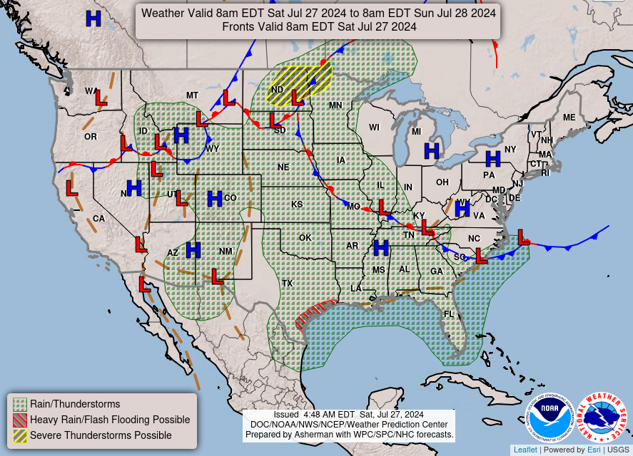
With a low pressure system over the Mid-South by Monday, and
another possibly developing offshore, rain chances are forecast to
spread into the Appalachians and Carolinas into the southern Mid-
Atlantic. The Marginal Risk still looks good in the Day 4/Monday
ERO, including the coastal rain and back into the south-central
Appalachians that can be sensitive to heavy rain causing flash
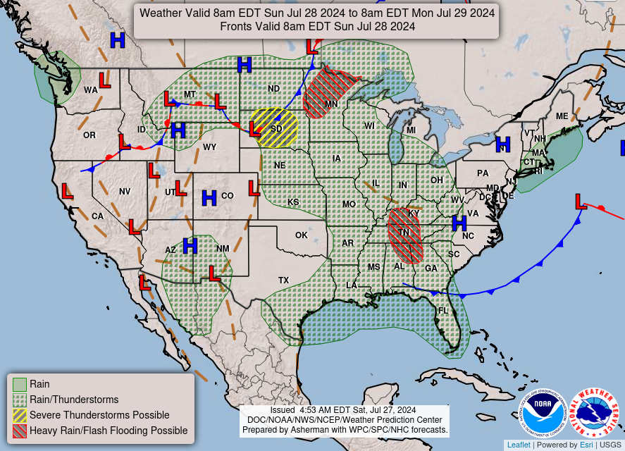
flooding. After that, recent changes in the model guidance show
less QPF into the Mid-Atlantic Tuesday, so removed the Marginal in
the Day 5 ERO there. Instead, areas of the Mississippi Valley into
the Ohio/Tennessee Valleys and Southeast may receive rain with the
low pressure system there. Will hold off on any ERO risk area based
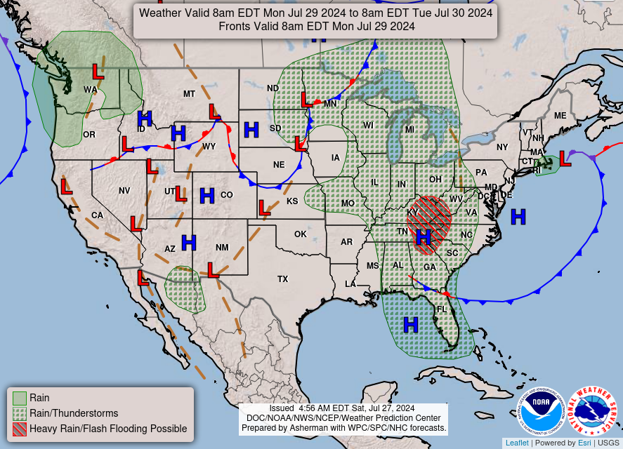
on concerns of limited instability and rain amounts. By Wednesday
rain could spread once again to the Southeast and Mid-Atlantic,
with uncertainty in the placement that continues to grow by
Thursday dependent on the low track. Continue to monitor forecasts
for future changes.
Snow across the Northwest looks to wind down on Monday after
higher elevations see some heavy weekend snow. The Pacific
Northwest should see additional rounds of rain and mountain snow
chances through the week as shortwaves and fronts move through.
Wednesday and Thursday may have a relative break before a renewal
of perhaps heavy amounts late week.
Cooler weather will be in place across the West early next week,
especially the Northwest through Monday where highs are forecast to
be 10 to 15 degrees below average. Temperatures should moderate
after Monday back to normal or even a little above normal.
Meanwhile, parts of the Plains will be near to above average early
next week before a cool down midweek as colder high pressure builds
in behind a cold front. Much of the East Coast region should
generally be below average through most of the forecast period,
though dependent on the uncertain pattern aloft.
Tate/Santorelli
Additional 3-7 Day Hazard information can be found on the WPC
medium range hazards outlook chart at:
https://www.wpc.ncep.noaa.gov/threats/threats.php
WPC medium range 500mb heights, surface systems, weather grids,
quantitative precipitation forecast (QPF), excessive rainfall
outlook (ERO), winter weather outlook (WWO) probabilities, heat
indices, and Key Messages can be accessed from:
https://www.wpc.ncep.noaa.gov/medr/5dayfcst500_wbg.gif
https://www.wpc.ncep.noaa.gov/medr/5dayfcst_wbg_conus.gif
https://www.wpc.ncep.noaa.gov/5km_grids/5km_gridsbody.html
https://www.wpc.ncep.noaa.gov/qpf/day4-7.shtml
https://www.wpc.ncep.noaa.gov/#page=ero
https://www.wpc.ncep.noaa.gov/wwd/pwpf_d47/pwpf_medr.php?day=4
https://www.wpc.ncep.noaa.gov/heat_index.shtml
https://www.wpc.ncep.noaa.gov/#page=ovw


