| WPC Met Watch |
|
|
Mesoscale Precipitation Discussion: #0184 |
|
(Issued at 1045 AM EDT Sat Apr 26 2025
) |
|
| MPD Selection |
|
|
|
|
|

Mesoscale Precipitation Discussion 0184
NWS Weather Prediction Center College Park MD
1045 AM EDT Sat Apr 26 2025

Areas affected...portions of Northwest TX into North TX and
south-central OK

Concerning...Heavy rainfall...Flash flooding likely

Valid 261500Z - 262100Z

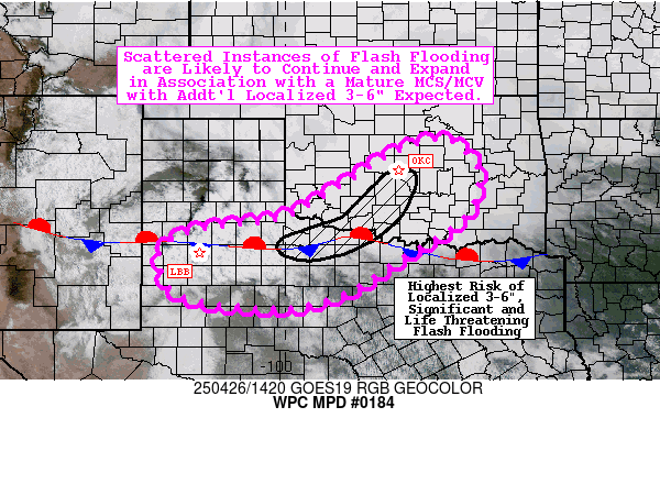
Summary...Scattered instances of flash flooding are likely to
continue and expand in association with a mature MCS/MCV with
additional localized totals of 3-6" expected (most likely from
Norman/OKC southwestward into portions of North TX). Localized
significant and life threatening flash flooding is possible.

Discussion...A mature MCS (mesoscale convective system) has
progressed southeastward out of the TX Panhandle and northwestern
OK from overnight into the morning, resulting in 6-12 hour
localized rainfall totals of 3-6 inches. The leading edge of the
squall line has reached a quasi-stationary surface boundary draped
from the southern Permian Basin eastward along and near the Red
River of the South. Some of the heaviest totals have occurred in
association with a well-defined MCV (mesoscale convective vortex)
and accompanying RIJ (rear-inflow jet), producing localized 3-6"
totals in the vicinity of Lawton, OK over just the past 3 hours
(with hourly totals as high as 2-3"). Most recent observational
trends support continued training and repeating of cells with
1-3"/hr rainfall rates along and near the path of the MCV/RIJ
(which should progress towards the northeast at near 20 kts within
the southwesterly mid-level flow). While instability is somewhat
limited on this trajectory (though MU CAPE of 500-1000 J/kg
extends northeast into the OKC/Norman metro area), the dynamics of
the MCV (as well as the influence of the right-entrance region of
a 90 kt polar jet streak over the Middle MS Valley) are providing
ample diffluence aloft with effective bulk shear of 30-40 kts.
Along the southern and southwestern flanks of the MCS, much more
ample instability (gradient of 1000-2000 J/kg of SB CAPE) with
appreciable low-level (850 mb) moisture transport via 20 kt LLJ
(low-level jet) should continue to support localized rainfall
rates of 1-2"/hr. Training and repeating of cells moving west to
east along the combined gust front and quasi-stationary boundary
may support excessive rainfall farther south into northwest TX as
well.

Primarily relied on hourly runs of the HRRR and experimental RRFS
since 06z, which are in remarkably good agreement (hour-to-hour
and between the two separate models). Additional 3-6 hour totals
as high as 3-6" are expected, though generally occurring to the
south and east of where prior rainfall has occurred (though some
additional overlap is possible, resulting in combined totals of up
to 8" in some localities from south of Norman, OK to the southwest
along and near I-44 to the Red River of the South). Very wet
antecedent conditions (with NASA SPoRT-LIS 0-1 m soil moisture
anomalies at or above the 90th percentile) have resulted in 3-6
hour FFGs (flash flood guidance) of 2.0-3.0 inches, suggesting
that additional scattered instances of flash flooding are likely
(and could locally be significant and life threatening,
particularly if these higher-end totals occur over metro areas).

Churchill

ATTN...WFO...FWD...LUB...MAF...OUN...SJT...TSA...

ATTN...RFC...ABRFC...WGRFC...NWC...

LAT...LON   36039651 35389590 34409620 33529759 32869861
            32500005 32770224 33670264 34060208 34250107
            34410000 35019889 35439824 35849754
Download in GIS format: Shapefile
| KML
Last Updated: 1046 AM EDT Sat Apr 26 2025
|


