| WPC Met Watch |
|
|
Mesoscale Precipitation Discussion: #0143 |
|
(Issued at 520 AM EDT Sat Apr 19 2025
) |
|
| MPD Selection |
|
|
|
|
|

Mesoscale Precipitation Discussion 0143
NWS Weather Prediction Center College Park MD
520 AM EDT Sat Apr 19 2025

Areas affected...portions of north/central Texas, far southern
Oklahoma

Concerning...Heavy rainfall...Flash flooding possible

Valid 190919Z - 191319Z

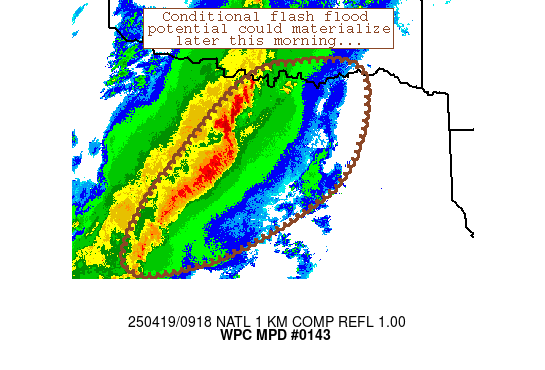
Summary...A linear convective complex may slow its forward speed
this morning, prompting an increase in rain rates and a
conditional flash flood threat.

Discussion...Convection initially over west Texas has grown
upscale into a lengthy linear complex extending from Mineral Wells
to Brady.  This complex continues to remain strong due to its
organization (mature cold pool), steep lapse rates aloft
(exceeding 7.5C/km), 2000 J/kg MLCAPE, and strong low-level flow
within the pre-convective environment.  The orientation of the
complex was parallel to southwesterly flow aloft, although
eastward propagation has held rain rates in check (generally less
than 1-1.5 inches/hr) so far this morning.

Some concern exists, however, that this convective band may slow
its forward progress this morning.  Mid/upper troughing continues
to deepen across Arizona, with falling geopotential heights across
the discussion area along with a very slight backing of flow
aloft.  The right-ward propagation of the complex was also
resulting in movement away from stronger mid/upper forcing for
ascent.  This slowing trend is hinted at in some CAMs, although
uncertainty exists due to poor handling of cold pool/mesoscale
dynamics.

Should this slowing trend commence, rain rates beneath the MCS
should increase and prompt isolated flash flood potential.
Underlying FFGs are quite high though (>2.5 inch/hr) with dry
soils noted per NASA Sport soil moisture data.  Isolated flash
potential would persist for as long as the MCS maintains its
intensity.  Impacts around the Dallas/Fort Worth metro area cannot
be completely ruled out.

Cook

ATTN...WFO...FWD...OUN...SJT...TSA...

ATTN...RFC...ABRFC...LMRFC...WGRFC...NWC...

LAT...LON   34069677 33899552 32429590 31409764 31009912
            31229966 31999933 32669877 33789763
Download in GIS format: Shapefile
| KML
Last Updated: 520 AM EDT Sat Apr 19 2025
|


