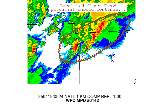
Mesoscale Precipitation Discussion 0142
NWS Weather Prediction Center College Park MD
426 AM EDT Sat Apr 19 2025

Areas affected...northeastern Oklahoma, northwestern Arkansas, far
southern Missouri

Concerning...Heavy rainfall...Flash flooding possible

Valid 190825Z - 191225Z

Summary...Areas of 1-3 inches of rainfall have occurred, with
heaviest totals estimated near Rogers, AR.  Upstream thunderstorm
activity should lead to a continued, but localized flash flood
threat for the next few hours.

Discussion...Training thunderstorms have produced localized areas
of 1-3 inches of rainfall along an an axis from just south of
Muskogee, OK to just west of Branson, MO since 05Z.  The heaviest
totals within this axis have fallen near Rogers/Springdale, AR per
MRMS estimates.  Moderate MRMS Flash responses are suggestive of
runoff issue in a few areas and also highlights the sensitivity of
local ground conditions.

Recent radar mosaic imagery suggests that additional rainfall will
occur across this axis over the next 2-4 hours or so.  A very
loosely organized convective complex extends from Muskogee
east-northeastward through Carroll County, AR that is oriented
favorably for training/repeating and local rain rates of 1
inches/hr at times.  Additionally, newer convection has
materialized near Oklahoma City that should migrate toward the
discussion area by around 11Z at the earliest.  A break in
convective activity exists between these storms and the
aforementioned Muskogee/Carroll MCS, however, which suggests that
there may be a brief temporal window for excessive runoff to
subside some before heavy rainfall re-enters the area.  Flash
flooding remains possible in this regime through at least 12Z.

Cook

ATTN...WFO...LZK...SGF...TSA...

ATTN...RFC...ABRFC...LMRFC...MBRFC...NWC...

LAT...LON   37329207 37069125 36719136 36019221 35229397
            35139538 35779561 36359513 36909374
Download in GIS format: Shapefile
| KML
Last Updated: 426 AM EDT Sat Apr 19 2025
| 


