| WPC Met Watch |
|
|
Mesoscale Precipitation Discussion: #0118 |
|
(Issued at 832 AM EDT Fri Apr 04 2025
) |
|
| MPD Selection |
|
|
|
|
|

Mesoscale Precipitation Discussion 0118
NWS Weather Prediction Center College Park MD
832 AM EDT Fri Apr 04 2025

Areas affected...Eastern OK...Western and Northern AR...Southern
MO

Concerning...Heavy rainfall...Flash flooding possible

Valid 041231Z - 041831Z

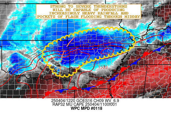
SUMMARY...Organizing clusters of heavy showers and thunderstorms
will pose at least some concern for pockets of flash flooding
going through midday.

DISCUSSION...The early-morning GOES-E WV suite shows a vigorous
mid-level trough gradually ejecting east out into the southern
High Plains which is interacting with a moist and unstable airmass
surging northward up into the Arklatex region and broader lower MS
Valley region along with proximity of a quasi-stationary front. A
strong southerly low-level jet of 30 to 40+ kts is overrunning
this front which is yielding substantial warm air
advection/isentropic ascent and a nose of elevated instability up
across areas of eastern OK, northern AR and southern MO.

Already there is a large cluster of strong to severe thunderstorms
impacting especially northeast OK and northwest AR where very cold
convective tops to about -75 C are noted. The convection is being
aided by strong kinematics with strong effective bulk shear
parameters (50 to 60+ kts) in place coupling with the nose of
elevated instability with MUCAPE values of 1000 to 2000+ J/kg.

This convection is expected to remain well-organized through the
midday time frame with the convection likely becoming more
pronounced eventually into areas of southern MO, but with
additional development impacting areas of eastern OK and western
to northern AR going into the early afternoon hours. This will be
supported by some further strengthening of the low-level jet
(reaching as high as 40 to 50 kts) up across eastern OK and
western AR by early this afternoon ahead of the upstream height
falls.

The aforementioned front will be lifting north as a warm front
with time, and this coupled with proximity of an inverted surface
trough poleward of the front will yield substantial low-level
convergence and forcing for convection. While there will be a
well-defined severe mode to the convection over the next several
hours, there will be sufficient levels of heavy rainfall that
pockets of flash flooding may begin to materialize. This will be
aided by 1 to 2 inch/hour rainfall rates and some rainfall totals
through 18Z (1PM CDT) of as much as 2 to 4 inches. The more
sensitive locations for runoff concerns should tend be over the
Ozark Plateau. However, there will also be urban runoff
considerations for flash flooding as well.

Orrison

ATTN...WFO...ICT...LSX...LZK...MEG...OUN...PAH...SGF...SHV...
TSA...

ATTN...RFC...ABRFC...LMRFC...MBRFC...NCRFC...NWC...

LAT...LON   37889085 37598974 36888920 36178999 35259323
            34289432 34239542 34889594 35729655 36499615
            37319440 37769268
Download in GIS format: Shapefile
| KML
Last Updated: 832 AM EDT Fri Apr 04 2025
|


