| WPC Met Watch |
|
|
Mesoscale Precipitation Discussion: #0117 |
|
(Issued at 703 AM EDT Fri Apr 04 2025
) |
|
| MPD Selection |
|
|
|
|
|

Mesoscale Precipitation Discussion 0117
NWS Weather Prediction Center College Park MD
703 AM EDT Fri Apr 04 2025

Areas affected...Portions of the Ohio Valley and Central
Appalachians

Concerning...Heavy rainfall...Flash flooding likely

Valid 041103Z - 041530Z

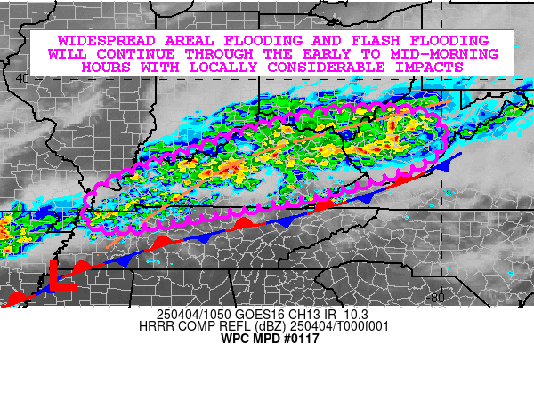
SUMMARY...Widespread areas of areal flooding and flash flooding
will continue through the early to mid-morning hours with locally
considerable impacts as additional rounds of heavy showers and
thunderstorms arrive. Some improvement expected by late morning.

DISCUSSION...The early-morning GOES-E IR satellite imagery along
with dual-pol radar shows an extensive axis of cold-topped
convection associated with heavy showers and thunderstorms
impacting large areas of Kentucky with an eastward extension of
this down into areas of western and southern West Virginia. The
convection continues to be supported by a south-southwest
low-level jet of 30 to 40+ kts with a nose of modest instability
characterized by MUCAPE values of as much as 500 to 1000 J/kg.

A somewhat complicated frontal structure is in place as well with
a surface frontal boundary situated across middle Tennessee and
into the central Appalachians with an inverted trough back to the
northwest of this over Kentucky that is more reflective of a
rather strong 850/925 mb front. The convergence along this feature
coupled with strong warm air advection and moisture transport over
the surface boundary is contributing to the extensive axis of
convection that still currently remains in place.

PWs across the region are generally on the order of 1.5 to 1.7
inches which is running about 2 standard deviations above normal
for this time of the year, and this continues to favor heavy
rainfall rates with aid from the low-level jet. Some rainfall
rates with the current activity continue to be upwards of 1 to 2
inches/hour, with some of the heaviest rates seen over central and
southern Kentucky and coinciding with the colder convective tops.

A series of very low-amplitude vort impulses embedded within the
stronger deeper layer west-southwest mid-level flow will tend to
support some sustenance of the convection at least for the next 2
to 3 hours, but the 06Z HREF guidance generally suggests an
overall weakening trend of the convection by later this morning as
this energy advances downstream and away from the region.
Additional rainfall amounts of 1 to 3 inches can be expected prior
to this.

Regardless, extremely sensitive soil conditions along with high
streamflows will support generally any additional rainfall going
right into runoff, with areal flooding and flash flooding likely
to continue this morning which will include locally considerable
impacts on the ground.

Orrison

ATTN...WFO...ILN...JKL...LMK...MEG...MRX...OHX...PAH...RLX...
RNK...

ATTN...RFC...LMRFC...OHRFC...NWC...

LAT...LON   39148251 38998040 38028020 37068290 36598543
            36118826 36268923 36888916 37498816 38018666
            38658487
Download in GIS format: Shapefile
| KML
Last Updated: 703 AM EDT Fri Apr 04 2025
|


