| WPC Met Watch |
|
|
Mesoscale Precipitation Discussion: #0114 |
|
(Issued at 725 PM EDT Thu Apr 03 2025
) |
|
| MPD Selection |
|
|
|
|
|

Mesoscale Precipitation Discussion 0114
NWS Weather Prediction Center College Park MD
725 PM EDT Thu Apr 03 2025

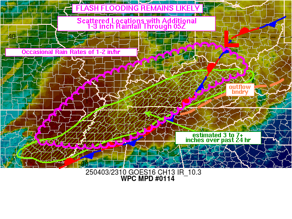
Areas affected...lower/middle MS Valley into OH Valley

Concerning...Heavy rainfall...Flash flooding likely

Valid 032323Z - 040500Z

SUMMARY...Additional rainfall of 1 to 3 inches over the next 6
hours is expected to continue areas of flash flooding from the
lower/middle MS Valley into the OH River Valley. Peak rainfall
rates of 1 to 1.5 in/hr (locally up to 2 in/hr possible) are
likely at times which will overlap, at least partially, with areas
that have ongoing flooding from heavy rainfall over the past 24
hours.

DISCUSSION...Regional radar imagery at 23Z showed scattered
thunderstorms over TN/KY, mostly north of a stationary front
analyzed from northwestern MS into Middle TN and eastern KY. A
greater coverage of thunderstorms was noted back to the west over
AR and southeastern MO, having originated back near the ArkLaTex
around 19Z. It appears the clusters of storms over AR/MO were
located ahead of a subtle low to mid-level shortwave, just nosing
into southwestern AR at 21Z, best identified in LPW imagery in the
850-700 mb and 700-500 mb layers.

The low to mid-level shortwave is likely to track northeastward
within southwest flow, allowing thunderstorms to spread
northeastward from AR/MO into the OH Valley overnight. Southerly
850 mb winds of 40-50 kt are forecast to overspread
western/northern TN into KY as the shortwave feature moves east,
maintaining an overrunning component of the stationary
front/outflow boundary combination over TN/KY. Elements of
training will be possible and sufficient elevated instability will
exist to support rainfall rates of 1 to 1.5 in/hr (locally up to 2
in/hr possible) within axes of training that develop.

The result will be an additional 1 to 2 inches (perhaps as high as
3" in isolated spots) through 05Z, resulting in continued areas of
flash flooding. It seems the bulk of the heavy rainfall threat
over the next 6 hours will fall north of the axis of heaviest
rainfall that fell over the past 24 hours, but some overlap along
the northern edges (northwestern TN into western/central KY) will
likely occur. These additional rains will exacerbate ongoing
flooding that is occurring across numerous locations of the MS
Valley into TN and KY.

Otto

ATTN...WFO...ILN...ILX...IND...JKL...LMK...LSX...LZK...MEG...
OHX...PAH...RLX...SGF...

ATTN...RFC...ABRFC...LMRFC...NCRFC...OHRFC...NWC...

LAT...LON   39558447 39288337 38518236 37998357 37348474
            36158627 35048842 34839010 34969138 35239235
            37009071 38108911 39198578
Download in GIS format: Shapefile
| KML
Last Updated: 725 PM EDT Thu Apr 03 2025
|


