| WPC Met Watch |
|
|
Mesoscale Precipitation Discussion: #0106 |
|
(Issued at 644 PM EDT Wed Apr 02 2025
) |
|
| MPD Selection |
|
|
|
|
|

Mesoscale Precipitation Discussion 0106
NWS Weather Prediction Center College Park MD
644 PM EDT Wed Apr 02 2025

Areas affected...ArkLaTex into mid-MS Valley

Concerning...Heavy rainfall...Flash flooding likely

Valid 022244Z - 030400Z

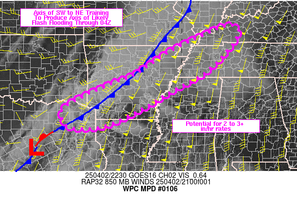
SUMMARY...There are growing concerns for an axis of heavy
rain/flash flooding to develop from near the ArkLaTex into western
TN/KY through 04Z. Peak rain rates of 2-3 in/hr will be likely
within axes of training, most likely across AR to the MS River.

DISCUSSION...22Z surface radar imagery and surface observations
depicted an elongated axis of thunderstorms stretching from
southwestern IL into southwestern AR. A cold front/outflow
boundary combination was located at the leading edge of the
thunderstorms and visible satellite/radar imagery showed cloud
streets and developing thunderstorms feeding into AR from the
south within 50-60 kt of flow at 850 mb (per area VAD wind plots).
The environment ahead of the cold front was moderately unstable
and very moist with MLCAPE of 2000 to 3000+ J/kg and PWATs of 1.7
to 1.9 inches per a special 20Z SHV sounding and 22Z SPC
mesoanalysis data.

Due to a lack of height falls over the Mid-South, south of an
advancing mid-level shortwave over the upper MS Valley, the
outflow (effective cold front) is forecast to steadily advance
eastward into the lower OH Valley over the next 3-6 hours, while
the southern end of the boundary stalls across the ArkLaTex. The
resultant orientation should align with the mean steering flow
from SW to NE. As robust low level moisture transport and
pre-frontal cells intersect the boundary, coverage of
thunderstorms should increase from near the ArkLaTex into eastern
AR and eventually into western TN/KY over the next several hours.
Areas of training will have the potential to produce 2-3 in/hr
rainfall rates and depending on the persistence of training over
any given location, some higher end rainfall totals (4+ inches)
could materialize.

Flash flooding appears likely within this setup and should overlap
of training occur with any urban centers, locally significant
flash flooding could occur.

Otto

ATTN...WFO...FWD...JAN...LZK...MEG...OHX...PAH...SHV...

ATTN...RFC...ABRFC...LMRFC...OHRFC...WGRFC...NWC...

LAT...LON   37438778 37018735 35378873 34359049 33259241
            32659396 32699536 33329565 33769524 34659337
            35029237 36189057 36958900
Download in GIS format: Shapefile
| KML
Last Updated: 644 PM EDT Wed Apr 02 2025
|


