|
|
|
Wingridds Macros (Scripts)
developed by the WPC International Desks
Since 2013, the WPC International Desks develop
Wingridds
macros/scripts to assess the potential for
weather processes that affect the Americas.
Access to a few of these, and installation instructions
are available in the following table.
Note that for the macros/scripts to work, you need to download the
ALIAS.USR
file and the color table files (available in the table).
There are two options to download any file:
(1) right click and download or (2) click, copy the text and save it with the file name.
|
Graphic description
|
File download and Description
|
|
ALIAS.USR
Updated on 23-Jan-2025
COMMAND FILE (MUST DOWNLOAD)
Contains variables programmed by the user, and is
required for the macros to work. Needs to be placed inside
the "C:/WINGRIDDS/USER" directory. To download:
(1) right click and download or (2) click, copy the text and save it with the file name.
|
|
GDIO.CMD
Updated on 23-Mar-2018
GDI, LOW-LEVEL MOISTURE
CONVERGENCE, 3-D FLOW, MID-LEVEL VORTICITY
AND UPPER DIVERGENCE
(HORIZONTAL ANALYSIS)
The macro provides a 3-D summary
of the thermodynamical and dynamical processes relevant to the
development of convection and rainfall in tropical and sub-tropical
locations.
It plots GDI-type stability (shaded), which relates to the potential
for different types of convection. Usually, greens/yellows and larger values
suggest that the potential for thunderstorms exist. Oranges and reds often
suggest that any convection that develops might have
the potential of producing heavy rainfall. More on GDI interpretation
can be found
here
.
The macro overlays low-level (1000-925-850 hPa) moisture convergence
(green contours and boxes), which captures the low-level triggering of
convection when moisture is available. This is important in features such
as fronts, shear-lines, waves/troughs in the trades, and areas of
orographically-induced convergence.
The low-level flow (1000-925-850 hPa) is overlaid using
barbs [kt] and streamlines in black.
Mid-upper flow (700-600-500-400 hPa) is plotted with white and yellow
barbs [kt] and streamlines.
Mid-level vorticity (red=positive and blue=negative) is used
to infer the presence of mid troughs and ridges;
and mid-upper divergence (600-500-400-300 hPa) are plotted
with white and yellow solid and dashed contours). The
latter relates to tropospheric ascent dynamically-induced by
mid/upper features.
This macro
needs to go inside your "C:/WINGRIDDS/MACROS/" folder.
Note: Requires the
ALIAS.USR
and the color table
CFCB.DAT
, both placed in the folder "C:/WINGRIDDS/USER".
|
|
TWIN.CMD
Updated on 23-Mar-2018
TRADE WIND INVERSION
(HORIZONTAL ANALYSIS)
Macro/script designed to evaluate the height and strength of the trade
wind inversion. This has implications in quantitative precipitation
forecasting, as it helps to describe the depth of the moist layer and
the vertical mixing with the overlying air.
It looks for the lowest potential inversion by calculating
vertical temperature gradients in 50-hPa layers and plots it
with a shaded color scale. Note that if many inversions are
present, the macro/script will only consider the lowest one.
The strength of the inversion is depicted with black boxes
(the larger the box, the stronger the inversion = the larger the temperature
increase with height). No box means a gentle lapse rate, but no
temperature inversion per say. Small boxes indicate increases of 0-2°C in
the layer; large boxes mean strong inversions.
The macro/script also plots low-level (1000-925-850 hPa)
moisture convergence (green contours and
boxes); precipitable water > 36mm (light blue solid contours), relative
humidity averaged over the 850-650 layer (orange or brown contours). The
the mid-level flow [kt] is then overlaid with white and yellow barbs and streamlines.
This macro needs to go inside your "C:/WINGRIDDS/MACROS/" folder.
Note: Requires the
ALIAS.USR
and the color table
CFCK.DAT
, both placed in the folder "C:/WINGRIDDS/USER".
|
|
GR01.CMD
Updated on 23-Mar-2018
HAIL POTENTIAL
(HORIZONTAL ANALYSIS)
Macro/script designed to evaluate the potential for hail in South America,
but generally works well in subtropical latitudes in both hemispheres,
particularly in the 25-40° latitude belt. The macro plots the 200-250 hPa winds
in gray shades, to reflect the presence of upper jets and the potential enhancement of
ascent by jet dynamics in association with jet maxima/streaks. Tropical-side entrances
of jet maxima/streaks and polar exits both favor
upper divergent and ascent.
The macro also plots wind barbs [kt] averaged over the 925-850 hPa layer in green,
to evaluate low-level convergence, especially in associations with
low-level jets. These are significant features in the triggering of severe convection
in South America. Also, 1000-850 hPa moisture convergence (light blue contours).
High mixing ratios at 500 hPa relate to enhanced growth of hail stones
in the level of supercooled water droplets. Thus, 500 hPa
mixing ratios >0.8 g/kg are plotted with blue contours. Mixing ratios
> 2 g/kg are ideal for hail growth. Some dry air in regions
were temperatures are slightly above freezing favor evaporative cooling,
a drop in temperatures, and preservation of hail stones that fall later.
Thus, 700 hPa relative humidity in the 45-70% range is plotted
(brown contours). Too much dry air (RH<40%) is often not good.
The boxes reflect the potential size of hail stones. These are based on the
700-500 hPa lapse rates, which reflect mid-level stability and relate to the
strength of the updraft. Lapse rates>20°C/layer associate with violent
updrafts (that help to maintain the hail stone longer on the growth layer)
and large hail (large red boxes); while lapse rates of 16-20°C
associate with small hail (small pink boxes).
This macro needs to go inside your "C:/WINGRIDDS/MACROS/" folder.
Note: Requires the
ALIAS.USR
and the color table
CFCX.DAT
, both placed in the folder "C:/WINGRIDDS/USER".
|
|
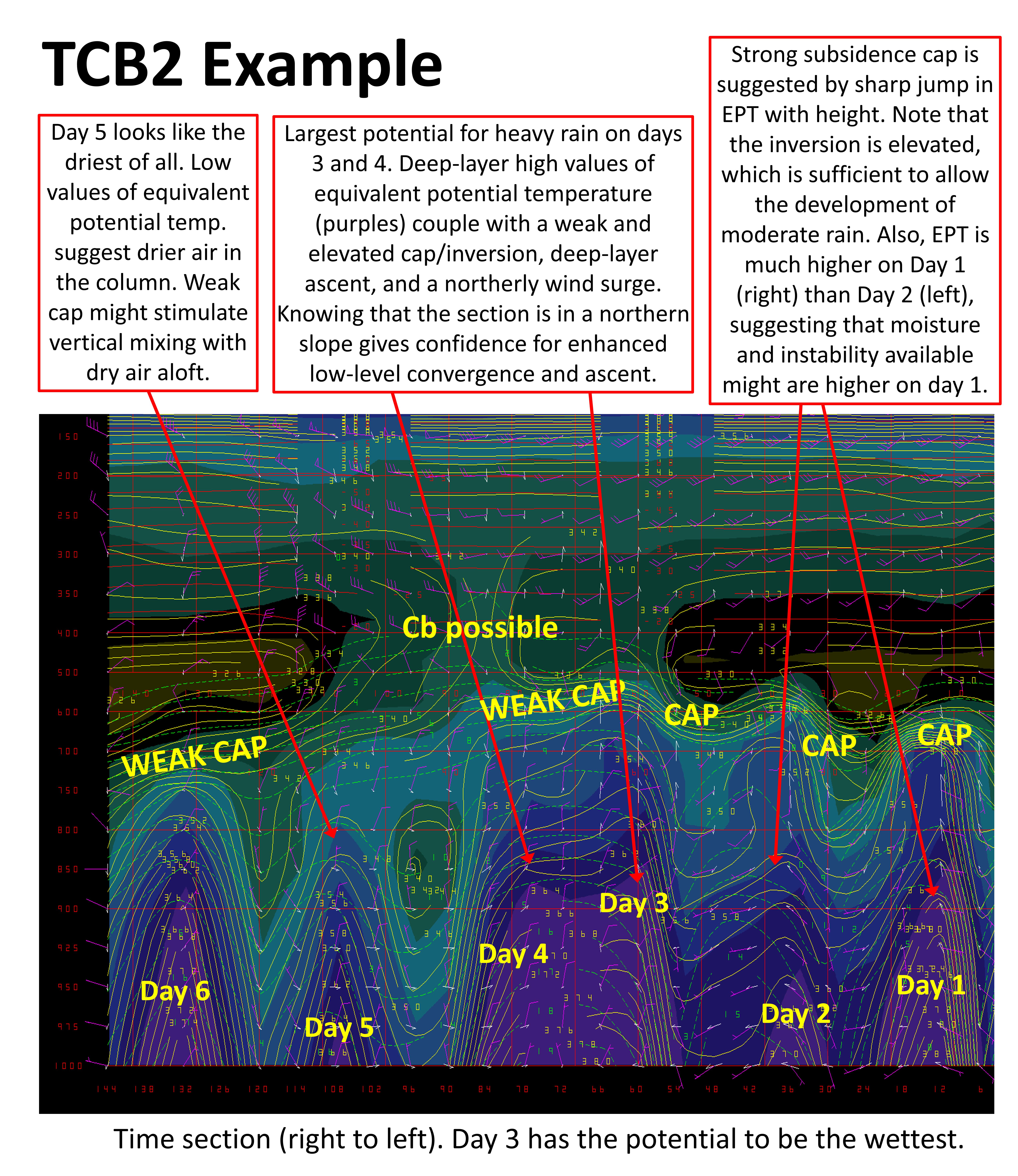
TCB2.CMD
Updated on 27-Mar-2018
POTENTIAL FOR CONVECTION AND RAINFALL:
INSTABILITY, WINDS, OMEGAS AND CB-TEMP
(VERTICAL CROSS/TIME SECTIONS)
Macro/script designed to evaluate the potential for convection and
precipitation, especially in tropical and subtropical regions. Shows
the vertical distribution of equivalent potential temperature
(shaded color field and yellow contours). This is related to the
heat and moisture content, and the potential for latent heat release.
The larger the values in the column, and the deeper the column, the
larger the potential for moist convection and the larger the
potential rainfall amounts.
It also shows wind barbs [kt] in magenta; omegas (white arrows);
mixing ratios (green dashed contours); and temperatures colder than
-20°C in solid red contours. The latter is to assess the potential
for electrification, as it becomes more likely once convection reaches
-20°C since this tops the likelihood for the development of ice
crystals (CB-TEMP=Cumulonimbus temperature).
This macro needs to go inside your "C:/WINGRIDDS/MACROS/" folder.
Note: Requires the
ALIAS.USR
and the color table
CFCT.DAT
, both placed in the folder "C:/WINGRIDDS/USER".
|
|
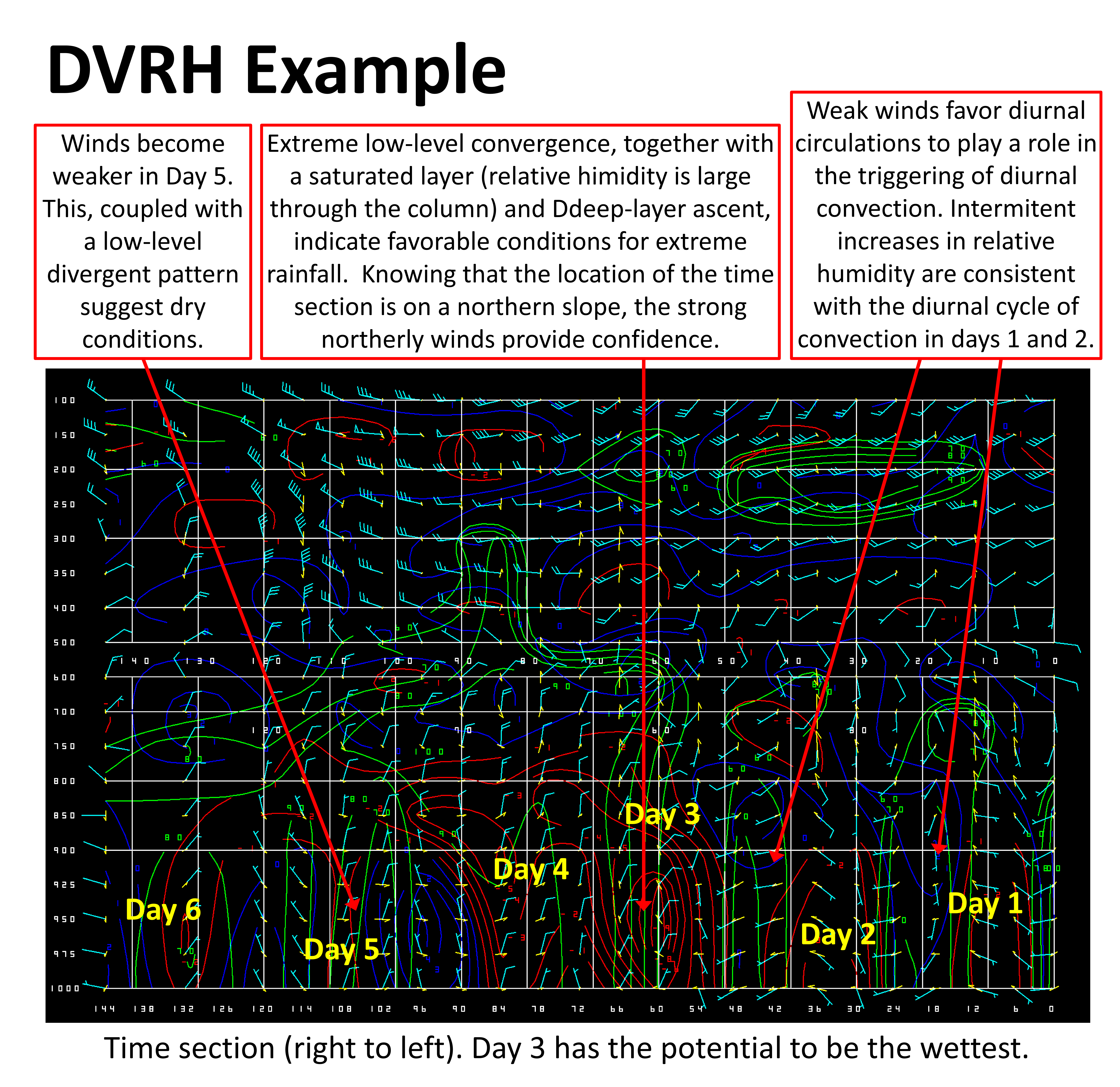
DVRH.CMD
Updated on 27-Mar-2018
DIVERGENCE, RELATIVE HUMIDITY, WINDS AND OMEGAS
(VERTICAL CROSS/TIME SECTIONS)
Macro/script designed to evaluate the vertical structure of convergence
and divergence, and its relation with vertical motion and saturation. It
includes horizontal winds [kt] and vertical motion (arrows).
It is used at the tropical desk on a daily basis to evaluate the potential
for moist convection enhanced by atmospheric dynamics.
This macro needs to go inside your "C:/WINGRIDDS/MACROS/" folder.
Note: Requires the
ALIAS.USR
but does NOT require a color table.
|
|
|


